Sunday, July 26, 2020

Dettifoss to Mývatn: Iceland tour Day 25

A very long day which included a steep climb and recent volcanics.

Owing to the rain outside playing maracas on my tent I packed my rucksack (with difficulty) in the very confined space inside. My socks have been wet for a few days, and now my sleeping bag has damp patches although it is still cosy and warm, maybe as it is synthetic rather than down. I left Dettifoss before any tourists had arrived a little apprehensive of the route ahead. I had downloaded it from the internet to reach the volcanic phenomena at Leirhnjúkur. As there are no trails from Dettifoss to Leirhnjúkur the route I had downloaded crossed much open land, and I was concerned that it may be difficult to push through the vegetation or other obstacles. From Dettifoss to the Hliðarhagi tourist hut it was not too difficult, the land only had low, gentle hills, and although it was necessary to jump from hummock to hummock at times, the undergrowth did not prove too difficult. Lichen and mosses; patches of red, splashes of white, furry greens, brightened my way. Even the river crossing I expected turned out to be dry. The tourist hut was open, with a note on the table warning of bed bugs on the mattresses.

After the hut things became difficult. There was no visible path up the hillside that followed, at least not in the right direction, and at first the creeping willow and birch made it difficult to push through. I persevered, following occasional sheep tracks. After the initial climb, the main obstacle to my walk came into view, a long ridge its summit lost in the low cloud. At first the route followed the base of the steep slope of the mountain's east face, then near a gully, turned to go over part of the mountain range. The climb was up loose scree at a high angle, sliding stone and gravel beneath my feet made more challenging as I was now in the clouds with poor visibility. To avoid some precipitous drops in the mist which hid everything more than a few metres away I needed to follow the route on my GPS very closely, its author clearly had the benefit of better visibility to pick the best way up. It was slow progress peering at my GPS while using my "sticks" to gain purchase and push me up on the steep, loose stones, but the climb did eventually give way to a plateau. After some downhill and a low ridge the trail suddenly hit a long, straight fault in the landscape, which created a cliff where the ground had dropped away into the mist. My route continued along its line for some way until it found a way down onto a bank of snow. I was pleased to join a vehicle track a little later which took me to the sights around Leirhnjúkur.

The first of these was the Krafla crater lakes, the water an attractive bluish white hue with some steaming and sulphurous fumaroles nearby. Joining the tarmac road a sign said that they had drilled into magma at around 2900 metres (must have been dramatic) and that there were reserves of hot water at shallower depths. A power station in the valley was using this geothermal energy, this hot water to produce electricity. Silver pipes spidered across a valley linking wells drilled to produce the hot water (or dispose of the waste) to the power plant. Orange domes had been placed on the wells. More smelly fumaroles were nearby, a wooden boardwalk, slippery with a film of wet clay and in a poor state of repair led me around them. Steam beached from holes in the beige coloured hills, which contrasted to the recent black lava flows which filled the valleys beyond. 

I had intended to wild camp somewhere in this area but thought I could make the Myvatn area by 7 or 8 pm where there would be more facilities. The path to Reykjahlíð was an exciting one, crossing recent lava with a ropey, pahoehoe surface, with caves and fissures to avoid stepping into. While it was fun jumping from one chunk of lava to another, the path also slowed me down. Once off the lava I did speed up although there were ascents and descents to cope with and photos to take (no point rushing and missing the whole point of the hike). Approaching 8 pm, I arrived at the campsite. I noticed they had some huts, and given the wet state of much of my stuff, I decided to stay in one, a chance to dry my socks!

Moss and lichens.
 
Hliðarhagi tourist hut.

One of the Kafla crater lakes.

Geothermal power station in the valley.

Recent black lava filling the base of the valley.

Lake Mývatn comes into view. 


Saturday, July 25, 2020

Jökulsárhlaup trail Ásbyrgi to Dettifoss: Iceland trip Day 24

A day following a gorge up to the giant and much visited Dettifoss waterfall.

It is raining on my tent as I write this, there has been drizzle from the dark clouds for much of the day, which did not show the landscape in its best light, a pity. The walk started well, among low birch and willow trees along the top of the cliffs that enclosed Ásbyrgi. Then, confused by a misleading sign, I took an unintended, longer path, which led me more directly to the gorge of the river Jökulsá á Fjöllum. I was following the Jökulsárhlaup trail, along which an annual "marathon" is run, the best time was 2 hours 3 minutes, it took me 10 hours 30 minutes! A large amount of turbulent, dirty water was flowing down the deep, wide gorge, in general the trail followed the rim giving a good view of the rocks and rapids below. I walked through areas of heathland with low creeping birch and willow, some heather and what looked like blueberry bushes; at other times the path was through rocks and ash. Near Vesturdalur there were some startling rock formations of twisted lava, before a parking area and campsite. On a sunny day I might have stopped for the night there and completed a few local hikes in the afternoon, but the site was almost closed and gloomy in the dull weather, a sign said you could camp if you paid the fee at Ásbyrgi visitor centre, 5 hours walk back down the trail! So continuing, there were further unusual rock formations, two rock towers in particular called "Karl og Kerling" were signposted. There were some wooden bridges but one river had to be waded across. Unlike a runner that passed me, I removed my boots to avoid wet feet for the next few days, although with the rain gradually seeping in they were pretty wet anyway.

Nearer Dettifoss a sign suggested you avoid the riverside path, especially if you had a rucksack, as it was steep and dangerous. Heeding the advice, somewhat reluctantly I followed a safer route away from the river beside a dry gorge, looking like a large "gash" in the land. The Dettifoss campsite, for hikers only, had no sign, just some plastic containers of drinking water and a visitors book. No-one was there so before pitching I continued to the car park thinking there might be an information office or sign, given the popularity of the site, but although there were plenty of cars, there were few facilities, just some long drop latrines. I followed the people walking from their vehicles down to the Dettifoss waterfall. I had seen a few waterfalls on my way up the gorge, but this was certainly the biggest, creating clouds of spray which merged with the rain, as vast volumes of water crashed over a lip of rock into the gorge below. A little higher up river there was another waterfall, Selfoss, more artistic with some of its flow diverted into smaller waterfalls on one side. With the visit to the waterfalls and some other diversions I covered 40 kilometres today with a 870 metre total ascent, a bit on the high side, but it is not much fun to sit around in the rain, you might as well walk.

Ásbyrgi.

Contorted labs flows by Vesturdalur.

"Karl og Kerling".

Looking up the gorge.

Dettifoss.

Selfoss.


Friday, July 24, 2020

Bláskógavegur to Ásbyrgi: Iceland tour Day 23

A wet walk to Ásbyrgi across heathland.

I woke to the rattle of rain on my tent, the same sound I fell to sleep with, and the wet weather continued until I reached Ásbyrgi. It was not the heavy rain allied with strong winds of a week ago which could soak you in a few minutes, but over a few hours it had the same effect. I was getting damp under my waterproof shell, my gloves dripping, my socks wet, damp patches spreading from the join between my waterproof jacket and waterproof trousers.

The Bláskógavegur was mainly a narrow path between low bushes that the man at the Ásbyrgi visitor centre told me were a type of dwarf birch. Patches of larger downy birch trees, but still only two or three metres high, straddled the path in patches, mixed with small willows. Water dripped on me as I brushed past them struggling on the slippery, muddy path. I saw a few sheep, who ran away on sight, and some birds, otherwise I had the world to myself. Fissures and cliffs, lying in a north - south direction were evidence that the ground was splitting apart here, as the American and European plates tried to separate from each other (I am sure there is some political analogy here).

Reaching Ásbyrgi just after midday I pitched my tent at the National Park campsite, checked out the visitor centre and had lunch in the busy roadside café. In the afternoon I completed one of the many circular walks in the area; up a cliff on stairs and with the help of ropes and then through birch woods. On a summer's day it would be delightful, or rather on a summer's day without semi-continuous rain.

Part of Bláskógavegur trail.

Climb up one of the cliffs that encircle Ásbyrgi, part of a circular walk.


Thursday, July 23, 2020

Bláskógavegur from Húsavík: Iceland trip Day 22

Today I began my walk from Húsavík to Ásbyrgi, on the little known Bláskógavegur trail.

My bus was leaving Akureyri at 8:30 am leaving time for Google to lead me to a bakery open by 7:30. The place it selected was a building that looked very like the nearby offices of Avis, KPMG and others, but inside the pastries and rolls were laid out on glass shelves and a group of older gentlemen were chatting over their breakfast at a nearby table. After coffee, ham filled croissant, an Icelandic doughnut and Skyr, I walked to the bus stop. Arriving a little early I admired the nearby display of poster sized photographs on an Arctic theme. While looking at a photo of the inside of a ladies hut in the north of Russia, meat dripping blood onto the floor, I noticed a small minibus sitting by the bus stop with "79" and the letter "S" in its window. "S" for Strætó the name of the bus company. After the driver had squirted antiseptic gel on my hands I joined an older couple on the minibus. They left at Laugar, so for the rest of the journey I was the sole passenger. 

Húsavík is known for its whale watching trips, and people were lining up on the quay to board boats. After purchasing a salt encrusted ham roll I left town on a road going east. I had chosen this route as the current bus service ends at Húsavík, leaving me the choice of hitch hiking to Ásbyrgi or walking (a taxi was just too expensive to consider for just me). On purchasing a hiking map (which later dissolved in the rain) I discovered the Bláskógavegur trail, an old pack horse route, headed in the required direction, starting after a length of road. On the map the road was a thin line, I assumed a gravel road serving a few outlining farms but instead it was two lanes of new black tarmac. I walked along it for almost 20 kilometres, a few cars passed, and a cyclist, but for most of the time I was a solitary, insignificant person walking alone, dwarfed by views of lakes, lupins and mountains as I slowly made my way over a watershed.

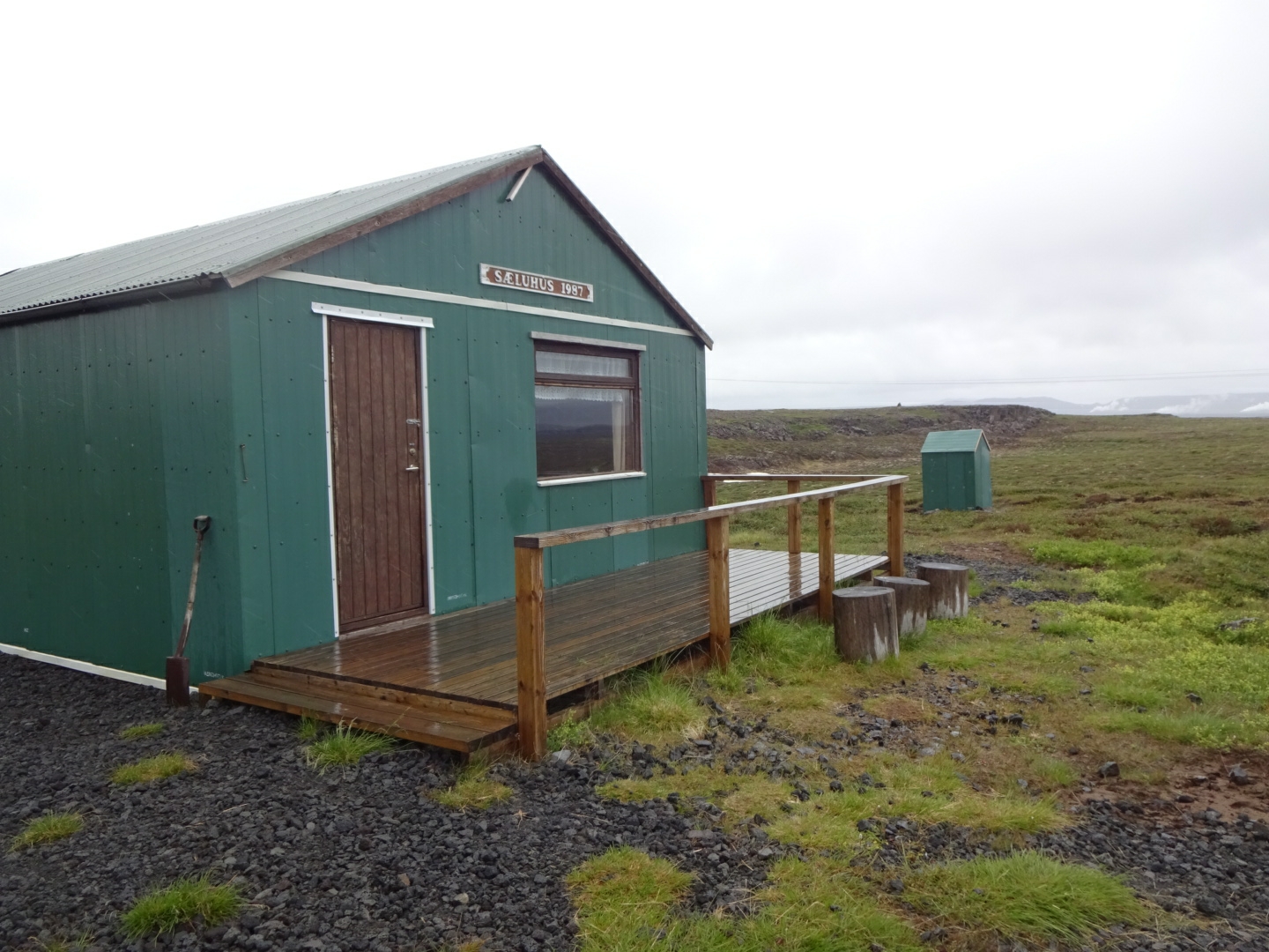
I left the road to follow a track by electricity pylons to reach the tourist hut at Sæluhúsmúli. The hut door was unlocked, inside there was a table, benches, a double decker sleeping platform and a variety of mops, cloths and cleaning products. As it had been raining for a few hours it made a comfortable place to eat my lunch. I contemplated spending the night there as the rain showed no sign of stopping, but as it was a little after 2 pm, there would have been a lot of time with little to do before bedtime. So, cleaning away my footprints as I backed towards the door, I left to continue my walk.

From the hut I was following waymarks on my GPS that I had copied down from the Internet, these led me along the Bláskógavegur. Over the day I saw two signs for the trail, not enough to be helpful given the junctions with other tracks. At first I was following vehicle tracks but then the route branched off onto a path. Footprints suggested the main users were horses and sheep. With the continuing rain and the churning effect of the horses hooves I was often slithering on mud. As the surrounding vegetation of low creeping, dwarf birch growing on hummocks was not easy to walk on I was condemned to slide on the narrow sunken path. Although there were some low hills and patches of rock, lava with a ropey pahoehoe surface, the area was pretty flat. I was close to the rift between the European and American plates and I assumed the lava was quite recent.

At around 5 pm Àsbyrgi was still 17 kilometres away in a straight line, and with the path taking a wiggly line, I was not going to get there tonight. Due to the low twiggy bushes I had trouble spotting a place to pitch my tent but at 5:30 a grassy patch proved too good to miss and I made camp for the night.
As I write this the rain continues, I hope it will stop tomorrow but the forecast is non-committal.

Earth, purple lupins, a lake and a mountain with patches of snow beside the road.

The road.

The hut.

Inside the hut.

The first  weathered Bláskógavegur sign.

The Bláskógavegur branching off on the right from a little used vehicle track it crosses.


Wednesday, July 22, 2020

Ísafjörður to Akureyri: Iceland tour Day 21

Today I flew into Iceland's second biggest town.

This morning I packed and caught the shuttle bus to Ísafjörður's small airport. Travelling down the runway, the steep, valley side, its slight curve towards the base artistically picked out by lines of scree, emerged in front of me as the plane headed for it. Fortunately the pilot banked the plane slightly as the wheels left the ground and we gradually gained height as we flew down the fjord below the mountain tops. The landing at Reykjavik was not quite so exciting. I was only there to change planes for the Akureyri flight (in truth it was the same plane, just heading in a different direction). The approach to Akureyri also meant dropping below mountain tops as the turboprop plane landed at the water side airstrip, using only half the runway.

I walked the short distance into town and after dropping off my bags at the hotel, visited the northern most Botanic Gardens. They were very well kept, I saw no weeds instead some beautiful flowers. Of most interest was not the massed blooms, but the section of Icelandic flora, where I attempted to put a name to the plants and flowers I had seen on my hikes. Not entirely successful as the names were in Icelandic and Latin, but not English. I visited the tourist information office which was in a large hall on the water front, only to find it had closed a little earlier at 4:00 pm, but in an adjacent area I listened to a couple singing in front of tables beside a bar where you could buy drinks. I would have liked to have sat down for a beer and enjoyed the music but as so often I have found, there was no space, all the tables were occupied. Considering I was visiting Iceland in the midst of a pandemic, many restaurants and venues seem to be full. It must be very overcrowded with tourists at other times. I consoled myself with a beer at the Backpackers Hostel, sharing a table with some fellow focused on the football playing on the big screen. 

As I would be on camping rations for the next few days, I decided I needed a healthy salad tonight with fresh leaves etc.. Google directed me into an industrial estate, where I almost gave up as it was far from the main drag. However, Google was right, "Salatsjoppan" just sold flavoursome salads. It was not that busy, its location was probably why I was the only one dining in.

Some of the decorative flowers at the botanic gardens.

One of the main thoroughfares of Akureyri, do not know who the girl is.


Tuesday, July 21, 2020

Hornvik to Ísafjörður: Iceland tour Day 20

A climb over a mountain then a cold wait for the ferry back to Ísafjörður.

Under a cloudy sky I walked across marshy land, avoiding a yellow summer house with "private" signs, to follow the path to Veiðileysa where my ferry would hopefully pick me up. Soon I was climbing up a succession of boulder strewn "steps", towards a high pass. On the other side of the pass, a view of Veiðileysufjörður opened out in front of me, an expanse of water enclosed by steep sides of ancient lava flows, stacked on top of each other, shaped into a fjord by some ice age glacier. The path was now indistinct, lost among boulder fields and patches of snow which made for slow progress. Aided by my GPS and stumbling over rocks I recovered the trail on lower ground where three fast flowing streams barred my way. There were stepping stones, many slightly underwater after recent rains and coated with moss, but using my trekking poles for balance and to provide support should my foot slip, I was able to safety cross without  slipping or the long and cold performance of removing my boots and trousers and wading through. 

Owing to an early start I had five hours to wait for the ferry, some of which I spent looking at the plants and flowers nearby, which included common spotted orchids and some small, delicate ferns. A few eider ducks passed by me on the fjord, otherwise there was little bird life, also surprisingly little flotsam left stranded on the beach, none of the plastic bottles and remains of fishing equipment you see in most places, just a few stranded jelly fish, mounds of seaweed and some scattered mussel shells. The facilities at my pick up point consisted of a latrine and a two signs, one with a picture of a boat. So I completed a few exercises, read my kindle and became increasingly cold. As the ferry time approached I was joined by a few others, reassuring me that I was at the right place.

Our boat ride back to Ísafjörður was rather more comfortable than the trip out, crossing calm waters without too much bouncing. With fewer people on board I was able to sit down in the cabin, watching the boat move across the map on the captain's Raymarine navigation system. We saw the glacier coming from the Drangajökull ice cap at the end of one fjord, the white ice merging with the white sky so parts of the black mountain seemed suspended in space. Now I am comfortably ensconced in my warm hotel after enjoying a hot shower and a dinner of cod and lentils, feeling slightly guilty as others on the boat were heading for a campsite. 

Looking down to Veiðileysufjörður.

Drangajökull ice cap. 

Monday, July 20, 2020

Around Hornvik Bay: Iceland tour Day 19

Today, a circular walk around the Horn peninsula that lies on the east of Hornvik Bay.

Leaving the campsite I crossed wet, flat land, trying to avoid the deeper pools of water while not damaging the vegetation. I noticed some fresh fox prints on the path and then surprised an arctic fox, which bounded off ahead of me. According to one of the people at the campsite they had spotted several in this area.

At the far side of the plain was a river. It was sluggish, wide, with a sandy bottom and the water came up to my knees. It was also extremely cold. After the river I walked along the edge of the bay. Eider ducks were guarding clutches of little chicks by the shore, gaudier Harlequin ducks preened themselves on rocks a little further out. Yesterday, I had also been surprised to see swans. There were a few houses at the old settlement of Horn, summer houses I assumed owned by people living in larger towns and visited on holidays. Nearby only low mounds in rectangular patterns marked out where old farms once stood, until, defeated by the harsh climate, isolation and poor land, the families left for more rewarding habitats. 

I climbed to the tip of the peninsula and continued along its east side, high cliffs dropping vertically down to the turbulent sea a few feet to my left. Sea gulls effortlessly soared above me, and their many nests on tiny ledges of rock on the cliff's face. I continued, moving inland a little to avoid higher peaks and any scary drops, admiring the geraniums and buttercup, spreads of pink and yellow beside my path. Returning to the cliff side, where I met the only other hikers out, I walked down towards the orange lighthouse, masts and associated buildings at Látravik. From there it was a climb up and over a pass, then down again to re-join my outward route and a repeat of the unpleasantly cold river crossing. 

Where I crossed the river.

Eider duck and chicks.

Cliffs of Horn peninsula. 

Hornvik Bay.

Látravik lighthouse.

Iceland hiking: some comments

Iceland has some diverse scenery. Close to the line separating the European and American tectonic plates, where new land is being formed, th...